In our time in Fort Chipewyan we seldom travelled into Wood Buffalo National Park - most of our recreation activities were on Lake Athabasca or on the eastern side of the Rochers River, so I have limited photographs to share. To provide a context for these pictures I had to first educate myself on the park. Other than a memory that there were issues with local people not being allowed to hunt or trap there I was pretty ignorant about its history or operation. After nearly ten weeks of reading, going down one rabbit-hole after another, I now understand that the park's past is riddled with failure in every way, an ugly blemish on our country's history, and a continuing embarrassment on the world stage. The bureaucratic bungling, misguided politics, systemic racism, commercial greed, inconsistent policies, and lack of local participation contributed to the general boondoggle the park has been. The park’s history is fraught with controversy, particularly regarding prohibitions and restrictions on indigenous rights that were clearly promised by Treaty 8 in 1899. I've learned that most affected were those whose homes and livelihoods depended on land within the park, and am chagrined that I didn't know how devastating the park's policies were for families whose names were familiar to me as a child –– Boucher, Bourke, Bruno, Champagne, Courtoreille, Deranger, Flett, Ladouceur, Laviolette, MacKay, Marcel, Marten, Mercredi, Paquette, Ratfat, Simpson, Trippe de Roche, Tuccaro, Vermillion, Wandering Spirit, and others. The challenge of reconciliation for the park's injustices is daunting, but seems to be progressing in jumps and starts. I've also developed a deeper understanding of the present industrial threats to the Peace-Athabasca Delta, arguably the world's largest inland freshwater delta, unique in its complex dynamics and ecological diversity as the confluence of water from the Peace, Birch, Athabasca and Fond-du-lac rivers.
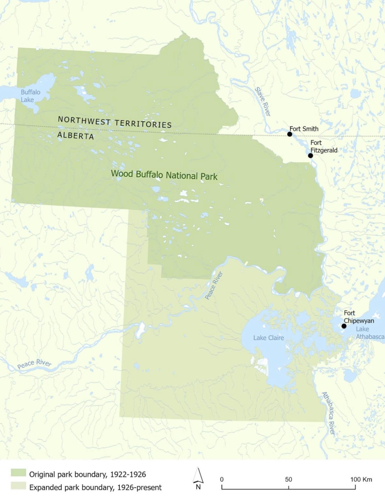
The largest national park in North America, it occupies 44,807 square kilometers on the NWT-Alberta border. Originally established in 1922 to protect wood bison from over-hunting, it was expanded in 1926 to control all hunting, trapping and other human activity in an attempt to maintain the area's wilderness and ecology.
 |
| This is the area of the park I had some experience with. The park's eastern boundary is across the Rochers River from Fort Chipewyan's Dog Head. The park includes English Island and the lakeshore up to an unused channel in the Embarras River delta, but not Potato Island. Most of the Peace-Athabasca Delta, a wetlands of rivers, creeks and perched basins whose complex hydrological dynamics are often oversimplified, is in the park. This geography has been actively evolving since the Laurentide Ice Sheet started retreating 12,000 years ago. Image from Google Earth. |
 |
| One of the finer residences in town, the park deputy warden's residence and office in Fort Chipewyan, September 1959. |
In late winter 1961 our family was invited by Corporal Bill Cutts to visit Sweetgrass Station in the park, using the RCMP Bombardier B Series snowmobile.
 |
| RCMP Corporal Bill Cutts, 1961 Bill was active in promoting community activities, particularly for youth. He coordinated the building of a curling rink, started a boxing club with William Moore, Justice of the Peace, and organized team sports. |
 |
| Mike, Mom and RCMP constable about to leave Fort Chipewyan. |
Our trip was a noisy rough 70 km ride over the delta country, following creeks, rivers and lakes. At one point the machine threw a track, requiring us to pry it back into place with makeshift tools and logs.
 |
| Arriving at Sweetgrass Station, 1961 We crossed the prairie southeast of the station. For generations local people had kept prairies open for bison by controlled burning of encroaching willows and small trees. This practice was outlawed by park administration for almost a century, resulting in reduced natural grazing and catastrophic forest fires as fuel accumulated. More recently local indigenous expertise helps guide fire management policy. |
 |
| Corral structures protecting the buildings at Sweetgrass Station, 1961. |
 |
| Park buildings at Sweetgrass Station, 1961. Only one of these log structures remains at Sweetgrass Station now. The station was closed in 1961 due to flooding. |
 From 1951 until 1964 the park was managed by the department's Northern Administration Branch whose mandate was economic growth. Values guiding the park's operations shifted emphasis from wildlife conservation to resource exploitation.
 Sweetgrass Station 1961.  This is now a destination for hiking tours, a 14 km walk from Sweetgrass Landing on the Peace River.  Although local people were not permitted to hunt bison in the park, bison meat was sold commercially.
  One of the communities of the Little Red River Cree Nation is Garden River, located on the north shore of the Peace River at the eastern terminus of Highway 58, 5 kilometers inside the park. Most of these peoples' traditional hunting, trapping and gathering lands have been under park administration since 1922. Consequently they have been subjected to nearly a century of inconsistent game regulations and prohibitions, invasive surveillance and distrust. For 60 years the community were not allowed to make enhancements to their village that the park considered too permanent, so they remained isolated and retained traditional Cree ways of bush survival (food sharing, autonomous leadership, labour division, rituals, spiritual relations with nature, knowledge through stories, etc.). They were refused reserve land until 2017, when, after 95 years, a small parcel of their territory, 37 km², was removed from the park and returned to them. The Garden River Cree have survived this ordeal with their cultural heritage intact.  | ||||
| In August 1964 a friend and I spent an afternoon exploring the Government Dog Camp at the forks on the Quatre Fourches River. This photo is taken facing south-south-west from the hill behind Dog Camp - about 20 dog houses are visible along the river shore. The river to the left leads to Fort Chipewyan on Lake Athabasca, the channel following the near right shore connects to the Peace River, and the channel following the far right shore leads to multiple connections to Mamawi Lake. Just outside of the left frame of the photo is a minor channel that leads to multiple creeks on Lake Athabasca. The direction of flow in these channels varies constantly, depending on weather events both locally and upstream on both the Peace and Athabasca Rivers, seasonal variations, ice-jam flooding on the Peace River and Athabasca rivers, wind seiches on Lake Athabasca, and hydroelectric regulation at the headwaters of the Peace River. |


 |
| This Google Earth image from 27 July 2019 shows the view covered by the previous photograph. It also illustrates the water flow in the Quatre Fourches on that day. The clear (dark) water from the south-east channel is merging to the west indicating the flow is out of the Lake Athabasca, while the slightly darker brown from Mamawi Lake appears to be flowing to the north, towards the Peace River. This darker water is probably from the Embarras River - a 1982 breakthrough into Cree Creek provides an unprecedented volume of water into Mamawi Lake. |
 |
| This map illustrates some of the major water flows in the Peace-Athabasca Delta. The water levels in the delta lakes was impacted heavily during the filling of the Williston Reservoir behind the Bennett dam between 1968 and 1971, resulting in much loss to wildlife and devastation to local trapping, fishing and hunting. The levels have recovered somewhat, but there continues to be disagreement about causes. Confounding studies is the lack of data - the only reliable historical records are of Lake Athabasca. Map from Canadian Parks and Wilderness Society |
 |
| Recording water levels at the Lake Athabasca water meter on The Point was my responsibility in the early 1960's. Twice a day, from breakup until the lake froze, I would walk or ride my bike, climb over the rocks, estimate the mean level of the lake on a meter-stick, and record the level and wind conditions. Alberta Water Resources Branch paid me $30/month - easy and welcome money for a young teenager. Now there are 13 automated meters in the delta area broadcasting levels over the internet every five minutes. Notice the water patterns in the image - a fairly brisk NE wind with the darker clear lake water flowing to the west and displacing the silty river water. Google Earth, May 9, 2004, about 3:00 PM. |
In July 1963 our family made a trip up the Quatre Fourches to the fire tower 12 km south of the Peace River.
 |
| We met the NTCL tug Radium Miner with barges of lumber from Swanson's Mill on the Peace River. |
 |
| Passing the Radium Miner on the Quatre Fourches. Note the dirty appearance of timbers closest to the tug, probably due to the 1963 ice-jam flood. Nearly 1.2 million board feet were lost, and another 2 million board feet were damaged at the mill site at Sweetgrass Landing. |
 |
| A park shelter on the shore of the Quatre Fourches, possibly at 58.786539°, -111.452063°. |
 |
| Fire Tower on the west shore of the Quatre Fourches at 58.816541°, -111.569304°. |
 |
| South-east view of the Quatre Fourches from the fire tower. The hill with the microwave tower behind Fort Chipewyan is on the horizon to the right of centre in the photo. |
In September 1964 I flew in Courier Flights Limited's Helio Courier to continue high school at Concordia College in Edmonton. On our way we flew northwest to Swanson's Lumber Mill to exchange mail before continuing to Fort McMurray and Edmonton.
 |
| The residential area of the Swanson's logging camp at Sweetgrass Landing on the Peace River, at 58.926841° -111.919215°. At its peak the camp had 200 residents, some commuting from Fort Chipewyan by boat or winter road. September 1964 |
 |
| Mill buildings at Swanson's logging camp. The trees on the shoreline are indicative of the size of the riparian old growth white spruce being harvested. The world's tallest white spruce are in the park, measuring 40-46 meters and up to 200 years old. In 1964 they were harvested individually with chainsaws, but by the mid-1980's mechanical feller-bunchers were introduced, the heavy machinery also destroying any unmechantable or deciduous trees in the way. The destruction of habitat for as much as 15,000 ha of forest has had devastating consequences for all life that the park is meant to protect: birds, vascular plants, mosses, lichens, mycorrhizal fungi, and mammals. |
 |
| A view of Swanson's facing SSE, with Lake Claire on the horizon. The mill operation spans the Claire River channel which has been a primary source of water into the delta to the south during spring flooding. Swanson's used the channel for disposing of cull lumber and milling waste - by the time the site was abandoned in 1972 it was completely blocked. 24 years later the park excavated the channel so water could flow again during spring ice-jam flooding of the Peace River. Interestingly, in October 1792 the Claire River was noted by Alexander MacKenzie as being navigable by canoe and Phillip Turnor's 1794 map shows it as a major route from the Peace River to Lake Claire, evidence of how much the delta landscape can change in a mere 200 years. |
 |
| Swanson's, a shareholder of Courier Flights Limited, built this airstrip to serve the mill. A similar one was built by Alberta Forestry Service in Fort Chipewyan, northeast of the cemetery and the RCMP detachment, on what is now Paquette Street. Note the level of the river; it would need to rise at least 20 feet to breech the bank, yet this has occurred multiple times during ice-jam floods. |
 |
| While it appears in this 2004 Google Earth image that the forest at Swanson's is recovering, in fact there has been less than 7% natural regeneration of the white spruce forests in the clearcuts. No planting has been done. 70% of the park's old-growth riparian forests have been lost to logging after over 40 years of timber extraction. The last timber berth in the park was extended in 1983, the same year the park was designated a UNESCO World Heritage Site. It was revoked in 1991 after environmental groups reminded Parks Canada that logging in the park contravened the National Parks Act enacted in 1930. Subsequently Canadian Forest Products (acting for Daishowa at the time), was paid $2,500,000 by the federal government to compensate for business opportunity losses. |
 |
| Radium Miner towing barges of lumber into Lake Athabasca, probably heading to the Athabasca River and on to Waterways rail head. Once out of the lake the barges will be pushed to navigate the river channel. Early summer 1961. |
 |
| Lumber and fuel drums at the government wharf in Fort Chipewyan, July 1963. The land on the horizon is in the park. Nottingham House (HBCo post from 1802-1806) was located on English Island in the bay at the right margin of the photo. |
 |
| Radium Miner stabilizing a leaking barge of park lumber while water is pumped out, July 1963. Notice the wildfire smoke haze on Potato Island and the hills in the park. |
Commercial fishing of goldeye and yellow pike-perch in the park's Lake Claire/Mamawi Lake waters was licensed to McInnes Products Corporation of Edmonton in 1948 and 1949, and later to Canadian Fish Producers of Winnipeg. The fish were frozen, sent by barge to Waterways, and on to Winnipeg by train to be marketed in the United States as "Lake Winnipeg Goldeye". No licenses were issued after goldeye stocks collapsed in 1966. Goldeye net fishing was done during June and July when they had migrated from the Peace River to the delta lakes for their annual spawn. It isn't clear if the goldeye population ever recovered, particularly after water levels in the lakes dropped during the 1968-1971 filling of the WAC Bennett dam. In addition to goldeye, the nets caught jackfish (pike), whitefish, chub, perch, suckers, and grayling, all of which were discarded, given to the dogs, or dried by indigenous families camped near the fishery. Only top quality goldeye were considered marketable - bruised, drowned or soft specimens were also wasted. This was very difficult for the local population to participate in and witness - most of the families had experienced extreme deprivation in the previous decades and despised wasting food.
 |
| I never saw commercial fishing in the park, and don't have any photos. This is the fishing plant run by local people in Fort Chipewyan in 1963. It didn't operate for long as marketable fish stocks collapsed. Sandy Bay, 58.716520°, -111.135020°, summer 1963. |
Although the park is now administered under Parks Canada's mandate to "...protect and present nationally significant examples of Canada's natural and cultural heritage, and foster public understanding, appreciation and enjoyment in ways that ensure the ecological and commemorative integrity of these places for present and future generations", there are pressures that are proving unmanageable, particularly regarding upstream energy extraction activities. The Site C dam project in British Columbia will soon be impacting water volumes on the Peace River, and the Fort McMurray Oil Sands activity continues to contaminate the Athabasca River with toxic seepage from tailings ponds. Mining and forestry activity is accelerating on the park's borders. Despite their environmental impact, they seem unstoppable. However, local organizations, such as the Athabasca Chipewyan First Nation, the Mikisew Cree First Nation, and the Fort Chipewyan Métis Association, have developed a strong voice. On July 3, 2019, a 10-person delegation from the Mikisew Cree First Nation and representatives of the Athabasca Chipewyan First Nation joined a long line of speakers to the UNESCO World Heritage Committee insisting that Canada take action to address the ongoing deterioration of the park. The committee agreed and gave Canada a deadline to demonstrate progress on specific issues. On June 22, 2021 UNESCO announced that these have still not been addressed and the park may need to be placed on the List of World Heritage in Danger. Of particular concern are overall watershed governance (involving BC, Alberta, Ottawa, and local communities) and the unresolved growth of toxic tailings ponds that are already leaking.
That both of these issues are directly related to our country's energy strategy makes them part of the climate crisis that we are embroiled in. If you're a Canadian reading this and want to make a difference, speak with your Member of Parliament. The cost of doing nothing is too high....
References
In no particular order, and without citation standards, these are some of the materials I accessed while posting my photos. Please let me know if any links quit working...
The Peace-Athabasca Delta: Portrait of a Dynamic Ecosystem, Kevin P. Timoney, University of Alberta Press, © 2013 Treeline Ecological Research Ltd. This large (595 pages) work provides a comprehensive examination of the science and history of the delta. Link to Book review and Preview. A result of many years of research by the author, it's a beautiful book, rich in detail and high-resolution illustrations. In my opinion it should be required reading in undergraduate programs in earth sciences. It is available on Amazon.
The logging of a world heritage site:Wood Buffalo National Park, Canada, The Forest Chronicle, October 1996, Kevin Timoney. A detailed analysis of the history of timber extraction in the park.
CPAWS response to the UNESCO World Heritage Committee regarding park issues.
Northern Bison Sanctuary or Big Ranch? Arcadia Collection, 2013, John Sandlos. A short article, with photos, of bison meat production at Hay Camp.
Flooding in the Peace-Athabasca Delta, Regional Aquatics Monitoring Program
Hydrology of Lake Athabasca, Hydrological Sciences Journal, 1973. This results of this study supported the development of the rock weir on the Rivière des Rochers.
Site C dam, oil sands pushing Canada’s largest national park closer to endangered list, The Narwhal, June 22, 2021
To Wood Buffalo National Park, with love, Briarpatch Magazine, September 10, 2020. Chloe Dragon Smith and Robert Grandjambe live and write from Moose Island in the park. This article is their vision of how the park could be managed with indigenous participation.
ACFN calls for harvesting rights in Wood Buffalo National Park, apology for mistreatment in park's creation, Fort McMurray Today, July 21, 2021
The Political Economy of Bison Management in Wood Buffalo National Park, Arctic Magazine, December 1992, Patricia McCormack. A history of the exploitation and threats to the park's bison.
Peace-Athabasca Delta Ecological Monitoring Program Not updated since 2015, but a good site for links and photos.
"We Used to Say Rats Fell from the Sky After a Flood": Temporary Recovery of Muskrat Following Ice Jams in the Peace-Athabasca Delta, Arctic Magazine, June 2018
Alberta River Basins Live monitoring of river conditions and water levels by Alberta Environment and Parks.
goldeye population, Canadian Wildlife Service, 1977
Wood Buffalo National Park: An Historical Overview and Source Study, Parks Canada, 1979
The Rise and Fall of Wood Buffalo National Park, Borealis Magazine, 1995
The Political Economy of Bison Management in Wood Buffalo National Park, Patricia McCormack, Arctic Magazine, January 1992
Death of a Delta, YouTube copy of a 16mm film, Film Frontiers, 1971. Contains disturbing and touching images of the impact of the low water levels in Mamawi Lake during the filling of the Bennett Dam.
N.W.T. 'bush kids' thrive at Sweetgrass Station, CBC, October 2017. Pictures of high school students from Fort Smith on their fall culture camp.
Indigenous groups request Wood Buffalo National Park apology, Cabin Radio, March 2021
A History of Relations between Wood Buffalo National Park and Athabasca Chipewyan First Nation - Report Release, Willow Springs Strategic Solutions, July 2021. Contains links to reports on extensive research into the impact of the park on displaced Denésuliné residents and land users.
Reports responding to World Heritage Committee, December 2020
A Report of the Lake Claire Goldeye Fishery for 1949, Fisheries Research Board of Canada, March 1950. This has details of the issues faced in the first two years of commercial fishing in the park.
Three Centuries of Change in the Peace-Athabasca Delta, Kevin Timoney, 2009. This short report, which has no free online access, contains a table of climatic, hydrological and biological events in the delta from 1710 to 2007.
How the (North) West Was Won: Development and Underdevelopment in the Fort Chipewyan Region, Patricia McCormack, Doctoral Thesis, Anthropology, UofA, Fall 1984. While difficult to read due to the poor microfilm copy, and long (619 pages), it is worth the effort. It reflects the author's in-depth understanding of regional issues built through her personal relationships with people from all segments of Fort Chipewyan's society in addition to traditional archival sources.
Northern parkland returned to Alberta First Nation after 95 years, Ninety-five years after Parks Canada swallowed a Cree village into Wood Buffalo National Park, the federal and provincial governments have returned the land to the Little Red River Cree Nation, Edmonton Journal, July 14, 2017.
No comments:
Post a Comment